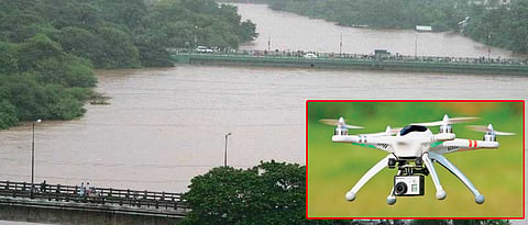

PUNE: The Pune Municipal Corporation (PMC) has taken pictures of flood-affected areas from the drone to find the reasons as to how the areas which were not a part of the blue line areas, got affected. This exercise is being undertaken as a precautionary measure to avoid damage due to floods.
The blue line of Mutha is defined at 60,000 cusecs but there was panic in the city when the discharge was 45-50,000 cusecs in the recent floods. The PMC has taken pictures with the help of drone to identify the flood-affected areas and compare it with the existing blue and red line of Mula-Mutha river.
With the help of a private agency, the civic body clicked drone pictures of Sinhagad Road, Yerawada, Kharadi, Baner-Balewadi and Aundh areas.
While speaking to Sakal Times, Municipal Commissioner Saurabh Rao said, “The purpose of the drone pictures is to determine why the flood affected areas outside the blue line. Is there any fault of the civic body while giving sanction to structures? Is something wrong in the planning of PMC? If our planning is right, what are the other reasons? Another thing is to check whether the blue line is only existing on paper or there is any physical existence at ground level. After analysing, we will be able to find out the reasons and solutions for that.”
He further added, “We are receiving unexpected rainfall. All dams are overflowing. Mula-Mutha rivers are getting water from three basin i.e. Khadakwasla, Pavana and Mulshi. Recently, water discharge was 1 lakh 40,000 cusecs at Bund Garden area in which Khadakwasla basin’s contribution was 49,000 cusecs.”
He pointed out, “In Aundh area, there was 25 feet of water in Jupiter Hospital. It is located 100 metres from the river. Besides that, there was 100 feet high retaining wall. Despite that, the area was flooded. People were saying that water was coming from drainage chambers. This was the situation in many parts of the city area where I visited.”
“Drone pictures will help us to identify areas which are not part of the riverside areas. It will also help us to find out whether there are other reasons such as encroachment of natural flows, nalas, inappropriate design of stormwater drain, drainage line etc.”
Red lines and blue lines are artificial lines demarcating the river area on the floodline. The red line is decided on the maximum water level possible once in 100 years and blue line is on maximum flood discharge in average 25 years. The prohibitive zone is the area between the two blue lines on the opposite side of the river, while the restrictive zone is the area between the blue line and red line.

