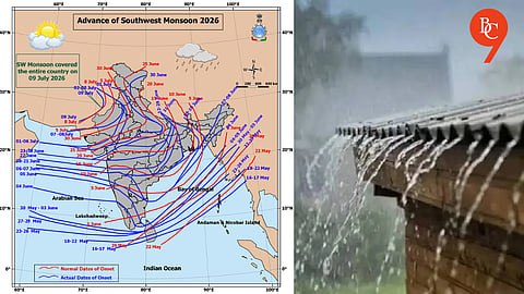


Pune, 10th July 2026: The southwest monsoon completed its advance across the entire country on July 9, just one day later than its normal date of July 8, according to weather observations. With this, the monsoon has now officially covered all parts of India.
The monsoon trough, a low-pressure belt extending from sea level to around 1.5 km altitude, has shifted slightly north of its usual position. It currently stretches from Anupgarh, Rohtak, Fursatganj, Dehri, Dhanbad and Bankura to Digha before extending into the Bay of Bengal.
This northward shift is expected to influence rainfall activity over several parts of the country.
After week of widespread heavy rainfall, the intensity of rain is likely to decrease across most parts of Maharashtra from Friday, July 10.
Weather conditions are expected to improve across Central Maharashtra, Marathwada and Vidarbha, with many places likely to experience longer dry spells and only isolated light showers. Some areas have already started witnessing clearer skies and breaks in rainfall.
While rainfall is expected to reduce across the state, Mumbai and the Konkan region are likely to continue receiving moderate rain, although the current spell of intense rainfall is expected to weaken.
Forecasters indicate that, apart from Konkan, the rest of Maharashtra could witness relatively stable weather with only scattered light rain over the coming days.
Between July 10 and July 19, much of Maharashtra, excluding Mumbai and the Konkan coast, is expected to experience a comparatively dry phase. The expected break in heavy rainfall could provide relief to flood-affected areas and allow water levels in rivers and reservoirs to stabilise, even as isolated showers remain possible.
